
Keyword
Research Voyage: IN2018_V07
15 record(s)
Type of resources
Topics
Keywords
Contact for the resource
Provided by
Formats
Update frequencies
Status
draft
-
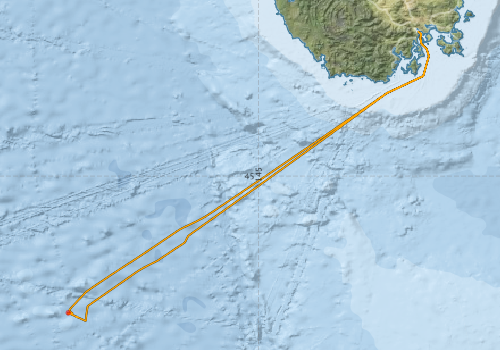
This record describes multibeam echosounder data collected on RV Investigator voyage IN2018_V07, SOTS: Southern Ocean Time Series Automated Moorings for Climate and Carbon Cycle Studies Southwest Tasmania which departed Hobart on the 20/08/2018 and returned to Hobart on the 25/08/2018. The Kongsberg EM710 MKII multibeam echosounder was used to acquire seafloor bathymetry and backscatter information between Hobart and the mooring deployment site. The EM710 MKII provides a 0.5° by 1° transmit and receive angular resolution respectively. The echosounder's nominal frequency range is from 40 to 100 kHz. Data are stored in *.all raw format for bathymetry and backscatter at CSIRO. There are 21 files totalling 2.27 GB of raw data in this dataset. Sound velocity profiles were applied to this data during data acquisition. Bathymetry data contained in *.all format are corrected for motion and position. Tide corrections were not applied to the processed data. Processed data has had outliers removed. Processed line data are available in *.gsf and ascii format, and processed bathymetry and backscatter grids in geotiff format. Additional information regarding this dataset, including further information on processing streams, is contained in the GSM data acquisition and processing report. Additional data products may be available on request.
-
This record describes sub bottom profiler data collected on RV Investigator voyage IN2018_V07, SOTS: Southern Ocean Time Series Automated Moorings for Climate and Carbon Cycle Studies Southwest Tasmania which departed Hobart on the 20/08/2018 and returned to Hobart on the 25/08/2018. The Kongsberg SBP120 (sub bottom profiler) was used to acquire data containing the specular reflections at different sediment interfaces below the seafloor. The SBP120 provides a 3° by 3° angular resolution. The echosounder's frequency sweep range is from 2.5 to 7 kHz. The SBP120 was logged sporadically for the extent of the voyage. Data are stored in *.raw (60 files 1.3 GB) raw and *.seg (49 files 1.3 GB) segy formats at CSIRO. The segy format data had a real time processing stream applied, which applies gain, a gain correction, matched filter with replica shaping, an attribute calculation for instantaneous amplitude and time variable gain. Additional information regarding this dataset is contained in the GSM data acquisition and processing report. Additional data products may be available on request
-
This record describes multibeam echosounder data collected on RV Investigator voyage IN2018_V07, SOTS: Southern Ocean Time Series Automated Moorings for Climate and Carbon Cycle Studies Southwest of Tasmania which departed Hobart on the 20/08/2018 and returned to Hobart on the 25/08/2018 The Kongsberg EM122 multibeam echosounder was used to acquire seafloor bathymetry, backscatter information between Hobart and mooring deployment site and return. The EM122 provides a 1 degree by 1 degree angular resolution. The echosounder's nominal frequency is 12 kHz. Data are stored in *.all raw format for bathymetry and backscatter at CSIRO. There are 83 files totalling 2.46 GB of raw data in this dataset. Sound velocity profiles were applied to this data during data acquisition. Bathymetry data contained in *.all format are corrected for motion and position. Tide corrections were not applied to the processed data. Processed data had outliers removed. Processed line data are available in *.gsf and ascii format, and processed bathymetry and backscatter grids in geotiff format. Additional information regarding this dataset, including information on processing streams, is contained in the GSM data acquisition and processing report. Additional data products may be available on request.
-
This record describes scientific split-beam echosounder data collected on the RV Investigator voyage IN2018_V07, SOTS: Southern Ocean Time Series Automated Moorings for Climate and Carbon Cycle Studies Southwest Tasmania which departed Hobart on the 20/08/2018 and returned to Hobart on the 25/08/2018. The Simrad EK60 split beam echosounders 18, 38, 70 120, 200 and 333 kHz were used to acquire acoustic backscatter data to a range of 1500 m, between Hobart and the mooring deployment site and return. All frequencies were logged continuously for the extent of the voyage. The all frequencyies were set to passive for the whole of the voyage. Data are stored in *.raw, *.bot and *.idx format at CSIRO. There are 591 files totalling 19.2 GB of raw data in this dataset. No processing has been conducted on this data. Additional information regarding this dataset is contained in the GSM data acquisition and processing report. Additional data products may be available on request.
-
This record describes the Acoustic Doppler Current Profiler (ADCP) data collected from the Marine National Facility RV Investigator voyage IN2018_V07, titled: "SOTS: Southern Ocean Time Series automated moorings for climate and carbon cycle studies southwest of Tasmania." The voyage took place from Hobart (TAS) to Hobart between August 20 and August 24, 2018. Data was collected during in2018_v07 for the duration of the voyage. Data was collected using UHDAS and post-processed using CODAS. Both the RDI Ocean Surveyor 150kHz ADCP and the RDI Ocean Surveyor 75kHz ADCP were run in narrowband. Internal triggering was used. The drop keel was at intermediate extension, around 8.5m below the waterline, for the duration of the voyage. The University of Hawaii’s CODAS software dated 2017-10-01 was used for data post-processing. Data coverage and quality is generally good. The ADCP was switched off during triangulation after mooring deployment. This dataset was processed and then archived within the CSIRO Oceans and Atmosphere (O&A) Information and Data Centre (IDC) in Hobart.
-
This record describes the Conductivity-Temperature-Depth (CTD) data collected from the Marine National Facility RV Investigator voyage IN2018_V07, titled: "SOTS: Southern Ocean Time Series automated moorings for climate and carbon cycle studies south west Tasmania; The voyage took place from Hobart (TAS) to Hobart between August 20 and August 24, 2018. Data for 1 deployment was acquired using the Seabird SBE911 CTD unit 24, fitted with 36 twelve litre bottles on the rosette sampler. Sea-Bird-supplied calibration factors were used to compute the pressures and preliminary conductivity values. CSIRO -supplied calibrations were applied to the temperature data. The data were subjected to automated QC to remove spikes and out-of-range values. The final conductivity calibration was based on a single deployment grouping. The final calibration from the primary sensor had a standard deviation (S.D) of 0.0011658 PSU, within our target of ‘better than 0.002 PSU’. The standard product of 1dbar binned averaged were produced using data from the primary conductivity and secondary oxygen sensors. The dissolved oxygen data calibration fit had a S.D. of 0.33778 uM. The agreement between the CTD and bottle data was good. A Biospherical photosynthetically active radiation (PAR) meter, Seapoint Turbidity Meter (Nephelometer) and a Chelsea Fluorometer were also installed on the auxiliary A/D channels of the CTD. The collected data were subsequently processed and archived within the CSIRO Oceans and Atmosphere (O&A) Information and Data Centre (IDC) in Hobart. Additional information regarding this dataset may be contained in the Voyage Summary and the CTD Data Processing Report.
-
This record describes Hydrology (HYD) data collected collected from the Marine National Facility RV Investigator Voyage IN2018_V07, titled: "SOTS: Southern Ocean Time Series automated moorings for climate and carbon cycle studies south west Tasmania; The voyage took place from Hobart (TAS) to Hobart between August 20 and August 24, 2018. Water samples collected for nutrients, dissolved oxygen, and salinity were assayed in the ship’s hydrochemistry laboratory during the voyage. Data quality: GOOD. Five nutrients determined: silicate, phosphate, nitrate + nitrite, nitrite and ammonium. The certified reference seawater results were within the specified limits. High quality data was produced for the three measured parameters. This dataset has been archived at the CSIRO O&A Information and Data Centre (IDC) in Hobart. Additional information regarding this dataset is contained in the Voyage Report and Data Processing Report.
-
NOTE: THis voyage has been delayed from the planned departure date because of weather conditions at the deployment site. This record describes the Underway (UWY) data collected from the Marine National Facility (MNF) RV Investigator Voyage IN2018_V07, titled: "SOTS: Southern Ocean Time Series automated moorings for climate and carbon cycle studies southwest of Tasmania." The voyage took place between August 20 and August 24, 2018 departing from Hobart (TAS) and arriving in Hobart. Standard Underway data is continuously recorded, consisting of: (1) Navigation data (NAV): Latitude, Longitude, Speed, Heading, Course Over Ground, Gyros, and Doppler Log (dual GPS instrument). (2) Thermosalinograph (TSG): Water Salinity, Flow-Rate, Temperature, Fluorescence, pCO2 and Optode/Oxygen. (3) Atmospheric (MET): Humidity, Wind Speed and Direction (vane and ultrasonic), Radiometer/Sea Surface Temprature, Pyranometer/Solar Radiation, Photosynthetically Active Radiation (PAR), Air Temperature, Air Pressure, Rain, Ozone and Trace Gases (port and starboard instruments). The quality-controlled RV Investigator underway meteorological and SST data are supplied to the IMOS AODN where they are publicly available at the "Ships of Opportunity" Thredds server (http://thredds.aodn.org.au/thredds/catalog/IMOS/SOOP/SOOP-ASF/VLMJ_Investigator/catalog.html) for research. From there, they are downloaded by NOAA for their In Situ Quality Monitoring web site (iQUAM2) and made available for satellite SST validation. The SBE 38 SST data are used within the Australian Bureau of Meteorology for real-time satellite SST validation and ingested into real-time SST analyses which are then used as the boundary condition for Numerical Weather Prediction models. The meteorological and SST data are uploaded onto the Global Telecommunications System (GTS) for global dissemination to Meteorological Agencies, and separately supplied to the SAMOS (http://samos.coaps.fsu.edu/html/) Project for air-sea flux research. The real-time SBE 38 SST data are currently (2017) used in the following data products (accessed via the GTS): • International Comprehensive Ocean-Atmosphere Data Set (ICOADS R3.0) (http://icoads.noaa.gov/) • NOAA NCEI Extended Reconstructed Sea Surface Temperature version 4 (ERSST.v4) (https://www.ncdc.noaa.gov/data-access/marineocean-data/extended-reconstructed-sea-surface-temperature-ersst-v4) • Hadley Centre SST Data Set (HadSST3) (http://www.metoffice.gov.uk/hadobs/hadsst3/) • Global Ocean Surface Underway Data (GOSUD) Project (http://www.gosud.org/) • Bureau of Meteorology daily and weekly SST analyses (http://www.bom.gov.au/marine/sst.shtml) • NOAA NCEI “Reynolds” daily global OISST analysis (https://www.ncdc.noaa.gov/oisst) • NASA JPL “MUR” 1 km daily global SST analysis (https://mur.jpl.nasa.gov/) • UK Met Office “OSTIA” daily global SST analysis (http://ghrsst-pp.metoffice.com/pages/latest_analysis/ostia.html) • CMC daily global SST analysis • Ourocean “G1SST” global daily 1 km SST analysis (https://ourocean.jpl.nasa.gov/SST) As part of the underway data gathering system, other datasets are produced (e.g., pCO2, ISAR SST) which are processed separately and have their own metadata records. Data are recorded at 5 second intervals. Near real-time data are available via the link "Visualisation tool for Underway Data." This dataset will be processed and archived within the CSIRO Oceans & Atmosphere (O&A) Information and Data Centre (IDC) in Hobart (TAS). Data are available at time intervals of 5 sec (NetCDF format), 10 sec and 5 min (ASCII format). Additional information regarding this dataset is contained in the Voyage Summary and/or the Data Processing Report for this voyage.
-
AusCPR: Phytoplankton Abundance. The Australian Continuous Plankton Recorder (AusCPR) survey is a joint project between CSIRO Oceans and Atmosphere (O&A) and the Australian Antarctic Division (AAD) to measure plankton communities as a guide to the health of Australia's oceans. The phytoplankton abundance data are analysed as per Richardson et al 2006. Phytoplankton are usually counted from water samples after settling but in the CPR analysis we count the phytoplankton in situ. With CPR samples, the phytoplankton is captured by the mesh and are caught by the silk strands, by phytoplankton mucilage, and/or by other organisms on the silk. It is thus possible to see the phytoplankton cells directly on the mesh. In essence, the phytoplankton is already concentrated. Washing the phytoplankton off the silks to count in the standard manner may result in loss of or damage to cells before analysis. It is advised that anyone using the data should first read this methodology or contact the project contact person. The aims of the AusCPR survey are to: * map plankton biodiversity and distribution * develop the first long-term plankton baseline for Australian waters * document plankton changes in response to climate change * provide indices for fisheries management * detect harmful algal blooms * validate satellite remote sensing * initialise and test ecosystem models. Servicing and maintenance of the CPRs and analysis of the samples for the AusCPR survey will be carried out by staff based at the O&A laboratories in Queensland and at the AAD in Hobart. The project was funded by the Integrated Marine Observing System (IMOS) and falls with the Ships of Opportunity facility. Data storage and access is planned to be interoperable with other national and international programs through the IMOS Infrastructure. Results from the AusCPR survey are available through the AODN portal: https://portal.aodn.org.au. For information on using the data please refer to the Richardson et al. 2006. As the taxonomic resolution of the data has changed over time, due to continual training, it is important that users refer to the change log tables included in your data download. These will provide information on the validity of the taxa, from what date we have been identifying certain taxa etc. Classification fields may be blank depending on the level to which that taxa has been identified, i.e. if only identified to family, genus and species will be blank. This data is freely available but please acknowledge all relevant parties, as detailed in acknowledgement section.
-
AusCPR: Zooplankton Abundance. The Australian Continuous Plankton Recorder (AusCPR) survey is a joint project between CSIRO Oceans and Atmosphere (O&A) and the Australian Antarctic Division (AAD) to measure plankton communities as a guide to the health of Australia's oceans. The zooplankton analysis is conducted differently to that described in Richardson et al 2006 as it is counted off the silk in a bogorov tray. This is accomplished by rinsing the silks in water and straining through a 10 micron mesh sieve. The collected plankton is transferred to a bogorov tray and counted under a dissecting scope. This is done to retain the phytoplankton. After counting the zooplankton and phytoplankton are stored with the silk segment in PGP preservative. AusCPR decided to analyse the zooplankton this way as it provides a more accurate analysis of the zooplankton present. It is easy to miss zooplankton when it is still on the silk and it is harder to identify. The aims of the AusCPR survey are to: * map plankton biodiversity and distribution * develop the first long-term plankton baseline for Australian waters * document plankton changes in response to climate change * provide indices for fisheries management * detect harmful algal blooms * validate satellite remote sensing * initialise and test ecosystem models. Servicing and maintenance of the CPRs and analysis of the samples for the AusCPR survey will be carried out by staff based at the O&A CSIRO laboratories in Queensland and Hobart and at the AAD in Hobart. The project was funded by the Integrated Marine Observing System (IMOS) and falls with the Ships of Opportunity facility. Data storage and access is planned to be interoperable with other national and international programs through the IMOS Infrastructure. Results from the AusCPR survey are available through the AODN portal:- https://portal.aodn.org.au. For information on using the data please refer to the Richardson et al. 2006. As the taxonomic resolution of the data has changed over time, due to continual training, it is important that users refer to the change log tables included in your data download. These will provide information on the validity of the taxa, from what date we have been identifying certain taxa etc. Classification fields may be blank depending on the level to which that taxa has been identified, i.e. if only identified to family, genus and species will be blank. This data is freely available but please acknowledgment all relevant parties, as detailed in acknowledgement section.